
As Built Surveys
ASES use Leica and Faro 3D laser scanning technology to carry out all as built surveys, the speed and accuracy of data translate into a cost effective solution without the…
View ServiceASES has over 15 years of experience in delivering an efficient, precise service to both public and private sectors. Our measuring services cover a wide range of applications, sectors and markets and our expert surveyors deliver a reliable, cost-effective solution every single time.
We offer a range of services below:
Land Surveys, Setting Out, Site Engineering, As-built Surveys, Control Networks, Measured Building Surveys (elevations, sections and floor plans), Monitoring Surveys, Elevation Surveys, Topographical Surveys, Structural Monitoring Services, 3D Laser Scanning, Dimensional Control, Volume Calculations, GPR Scanning, Utility Surveys, Global Navigation Satellite Systems (GNSS), Net Lettable Areas (NIA & GIA), Structural Steel Surveys.
ASES use Leica and Faro 3D laser scanning technology to carry out all as built surveys, the speed and accuracy of data translate into a cost effective solution without the…
View Service
ASES have extensive experience in implementing the latest 3D laser scanning technology to ensure cladding facades are accurately recorded prior to removal.
View Service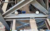
ASES embraces the technological advances to survey, capture and analyse accurate geometrical and geographic data into 2D or 3D.
View Service
ASES has carried out elevation surveys for a variety of purposes. From surveying entire street elevations for the purpose of Rights of Light analysis, to conservation facades…
View Service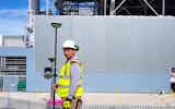
ASES uses Global Positioning System(GPS) to offer high level of accuracy and speed of use of the GPS Total Station allows “real-time” surveying. When the system is mounted on…
View Service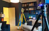
ASES have vast experience in House Plan Surveys from small domestic surveys to large Estates. The adoption of Laser Scanning allow ASES surveyors to reduce site time ,…
View Service
ASES have vast experience in Measured Building Surveys from small domestic surveys to large commercial projects. The adoption of Laser Scanning allow ASES surveyors to reduce…
View Service
ASES has experience in the correct installation, movement monitoring and reporting for residential and commercial developments. Movement Monitoring surveys offer the ability…
View Service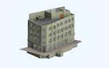
BIM projects for redevelopment or refit will usually begin their life cycle with a 3D Laser scan, our expertise enables us to correctly deliver a project of any size and…
View Service
With over 20 years’ of site experience ASES specialise in setting out at any stage of a project. We understand the importance of accuracy in setting out and pride ourselves…
View Service
ASES offer correctly traversing survey control and applying any necessary corrections, a tight, error free system can be assured. Local grids that are parallel to square…
View Service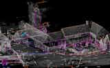
ASES have experience in carrying out accurate cost effective, Topographic Surveys for a wide range of sectors and clients, adapting the level of detail required to suit the…
View Service
ASES implement the use of Leica and Faro technologies with integrated high definition cameras to deliver highly precise laser scanning. ASES have successfully employed the…
View Service
With over 10 years’ experience in the industry, ASES Ltd offers a full range of utility detection services using electromagnetic detection and ground-penetrating radar (GPR)…
View Service
ASES adoption of 3D laser scanning and more recently UAV’s (drone) enables surfaces to be scanned more densely, remotely reducing the risks of traversing the surface of a…
View Service
ASES is proud to offer Matterport's cutting-edge 3D digital twin technology to transform how you plan, execute, and manage your projects, saving you time, reducing costs, and…
View Service
A Revit 3D Mesh Model may be the ideal model for your project. ASES have successfully scanned and modelled a variety of objects and structures, from Skeletons at the Natural…
View Service