
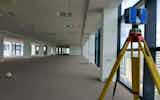
3D Laser Scanning
ASES implement the use of Leica and Faro technologies with integrated high definition cameras to deliver highly precise laser scanning. ASES have…
View Service
The purpose of an elevation survey is to establish the exact shape or any features of a specific object’s elevation. These comprehensive surveys capture structural details that might not be present in sections or floor plans.
ASES has carried out elevation surveys for a variety of purposes. From surveying entire street elevations for the purpose of Rights of Light analysis, to conservation facades that need accurate plotting to accommodate facade retention structural steelwork.
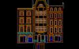
Our experienced staff are also commonly contracted to provide elevation surveys for cladding contractors to accurately record window opening sizes and positions.
Because of the varying specifications involved when performing an elevation survey, the advance of 3D Laser Scanning technology has had an extremely positive impact on the way that they are performed today.
The level of detail that can be recorded (which was not previously possible), combined with the scanner’s speed and precision, means that elevations can now be captured at millimetre precision.
All captured data can then be translated into a variety of deliverables to suit the project’s specific requirements. Deliverables such as a 2D CAD drawing can be supplemented along with a 3D point cloud or solid – which greatly improves visualisation and reduces your design time.
Another aspect that we care about is safety. With this latest technology, scanners can collect the majority of information from ground level or by use of telescopic tripod. This means that safety is greatly improved because there is no longer a need to access elevated heights.
We are ready to talk about your requirements to see how we can help you.


ASES implement the use of Leica and Faro technologies with integrated high definition cameras to deliver highly precise laser scanning. ASES have…
View Service